|
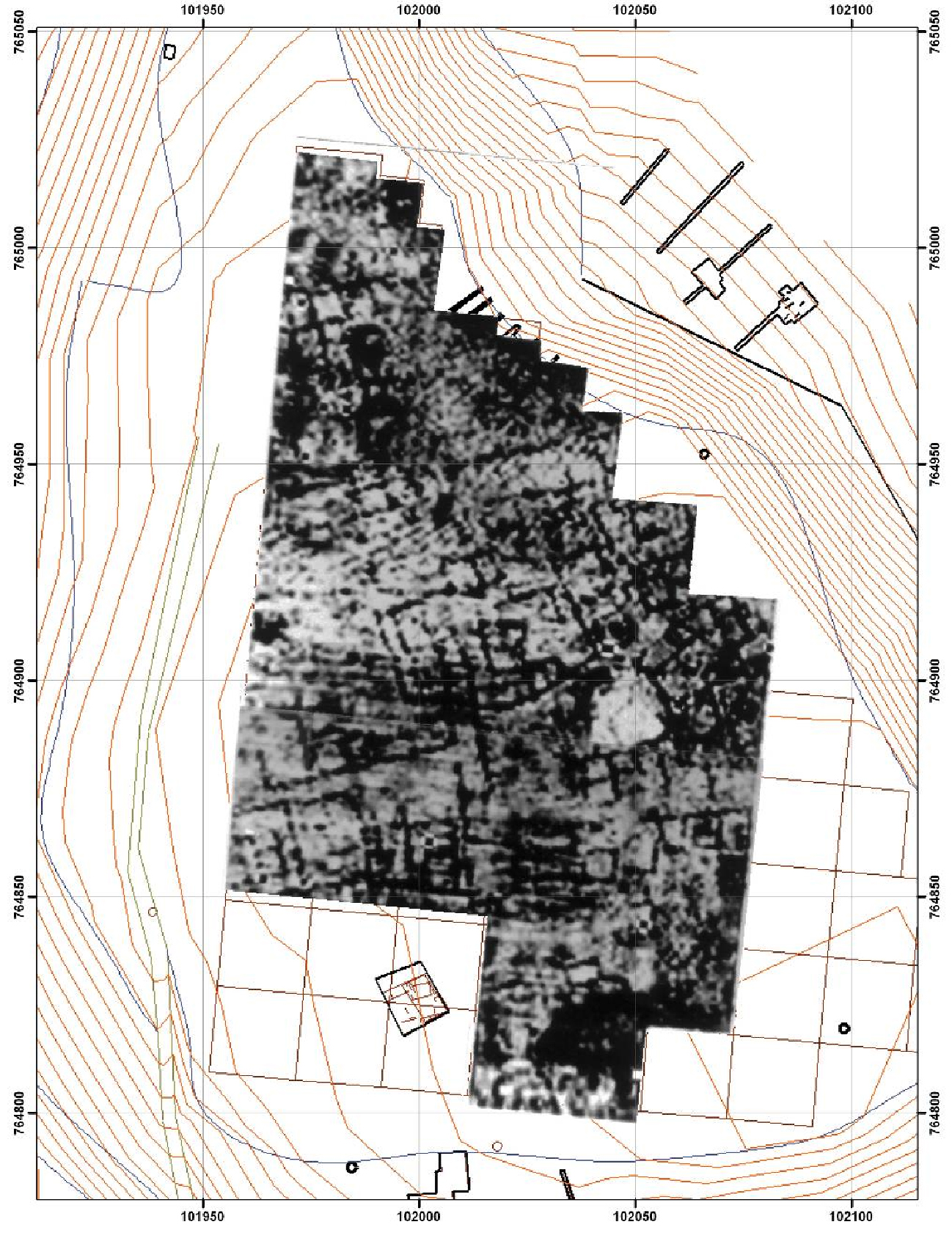
Geophysical prospecting is widely used all over the Globe to detect and map buried ancient remnants. It comprises an integral part of the archaeological survey and it is referred in any introductory book on the field archaeological methods. Practically it is consisted of an ensemble of different techniques which are all based on the different physical properties that antiquities pose with respect to the environment they are hosted in. The discernible physical properties create disturbances on natural or artificial fields which can be recorded and thus lead to the detection of their sources (causative structures). Further, techniques of processing and interpretation of these anomalies have been developed which allow assessment of the identity, dimensions and the burial depth of the subsurface structures. It is possible, under favorable conditions; to obtain finally an image which resembles the result that would have been drawn if an excavation had taken place. An example is given in Figure (1) where the plane view of the buried ancient remains is easily recognized. The particular example is from the site hosting the ruins of ancient Europos in Kilkis Prefecture (Region of Macedonia, North Greece). It is immediately evident that the ancient urban complex is revealed in this map. The use of images, like the one of the example, is valuable for the archaeological research: Excavation can be better planned and directed towards specific targets. Conclusions can be inferred based on the findings of archaeological trenches and the final geophysical images.
Fig. 1. The ancient ruins comprise resistive structures buried in a relatively conductive environment. Thus they create high resistance anomalies which are mapped by geophysical prospecting. In the particular example shown in this figure, the subsurface resistance has been mapped and its distribution is depicted in a grey scale. The darker tones indicate areas of high resistance which are presumably caused by the concealed ancient ruins. The example has been drawn from the exploration of the site hosting the ruins of the ancient city ”Europos“ in N. Greece[1]. The closed rectangular anomalies reflecting the presence of remnants of foundation walls form a plane view showing more or less the shape of the ancient urban complex.
Application of geophysical prospecting is cost and time effective since large areas are covered in a swift and reliable manner. Further, due to the relevant legislation in most of the European Countries, the geophysical images comprise evidences of the presence of concealed antiquities. Therefore, they can be even used in the courts to support cases of expropriation of lands. The relevant Greek law was published in FEK 153, 28/6/2002.
The Exploration Geophysics Lab. of the Aristotle University of Thessaloniki, headed by Prof. Gregory N. Tsokas, has conducted more than 250 surveys in Greece and abroad. Among the sites investigated, are included Aegae (Verghina), Dion, Europos, Mitrou island, Samothrace, Elis, Marathon, Santorini, the center of Athens, the Acropolis of Athens, Sparta, ancient Tenea, Thebes etc. Also, sites have been explored in Italy, Spain, Egypt, Russia, Kuwait, Jordan and Cyprus. Further, the members of the Exploration Geophysics Lab. have participated in large basic research projects on the development of the archaeological prospection. This is easily witnessed by the number of publications in the relevant international scientific journals.
[1] Tsokas, G.N., Giannopoulos,A., Tsourlos,P., Vargemezis,G., Tealby,J.M., Sarris,A., Papazachos,C.B., Savopoulou,T. A large scale geophysical survey in the archaeological site of Europos (northern Greece). ”Journal of Applied Geophysics“, 32, 85-98, 1994. |


